
Every year, millions of people experience severe weather that develops over just a few days—or even a few hours.
Modern forecasting technology allows meteorologists to identify potentially dangerous weather systems well before they arrive, giving communities valuable time to prepare. Whether it’s a powerful thunderstorm, tropical cyclone, winter storm, or large rain system, early warnings can help reduce risks to people, homes, and infrastructure.
When weather experts announce that a major storm is developing, it doesn’t necessarily mean severe impacts are guaranteed. Forecasts evolve as new data becomes available, and the exact track and intensity often change. That’s why staying informed is just as important as preparing.
Here’s how meteorologists monitor developing storms, what hazards they watch for, and what you can do to stay safe if severe weather threatens your area.
How Storms Develop
Storms form when several atmospheric ingredients come together.
While every weather system is different, meteorologists generally look for:
- Warm, moist air
- Cooler, drier air
- Atmospheric instability
- Wind patterns that encourage rising air
- Changes in air pressure
When these ingredients align, clouds can rapidly grow into powerful storm systems capable of producing heavy rain, lightning, hail, strong winds, or even tornadoes in some regions.
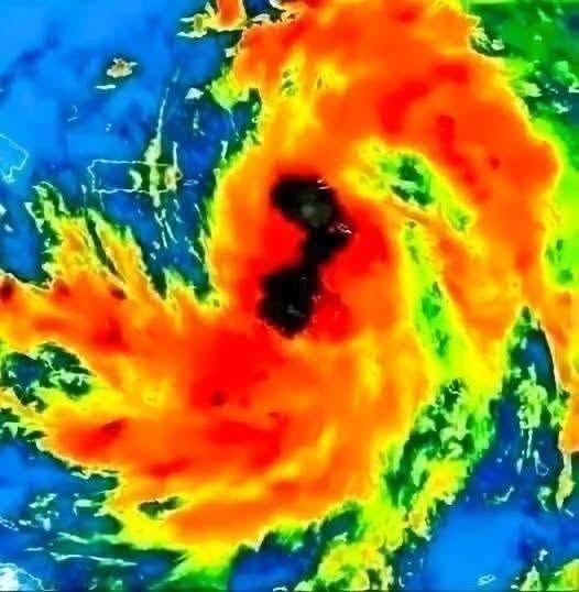
For tropical storms and hurricanes, warm ocean water provides much of the energy needed for development.
How Meteorologists Track Storms
Today’s weather forecasting relies on a combination of advanced technologies.
These include:
Weather Satellites
Satellites continuously monitor cloud development across the globe.
They help forecasters observe:
- Storm movement
- Cloud temperatures
- Moisture levels
- Storm organization
Satellite imagery often provides the earliest indication that a weather system is strengthening.
Weather Radar
Radar detects precipitation and monitors rainfall intensity.
It also helps identify:
- Thunderstorms
- Hail
- Wind patterns
- Rotation within storms
This information becomes especially important as storms approach populated areas.
Computer Forecast Models
Powerful computers simulate how the atmosphere may evolve over the coming hours and days.
These models analyze enormous amounts of data, including:
- Air pressure
- Temperature
- Humidity
- Wind speed
- Ocean conditions
Because different models sometimes produce different results, meteorologists compare several forecasts before issuing public warnings.
Why Forecasts Change
One common misconception is that weather forecasts should remain identical from day to day.
In reality, forecasts improve as new observations become available.
A storm predicted several days in advance may:
- Strengthen
- Weaken
- Slow down
- Speed up
- Change direction
Even small changes can significantly alter which communities experience the greatest impacts.
For this reason, experts encourage people to follow updates regularly rather than relying on a single forecast.
Possible Hazards During Severe Storms
Not every storm produces every hazard.
However, meteorologists often monitor the potential for:
Heavy Rainfall
Large amounts of rain falling in a short period can overwhelm drainage systems.
This increases the risk of:
- Urban flooding
- Flash floods
- River flooding
Floodwater may appear shallow while hiding strong currents.
Strong Winds
Powerful wind gusts can:
Next page